
The Route
With an idea of the cities and locations your travel group wants to see, you need to connect them with a route that makes sense—reducing transfers, double-backing, downtime, queues, and travel time.

Spreadsheet: Flights
With a high-level idea of locations you want to visit, you can dive into the flight options to reach your destination, and whether purchasing through dollars or miles.
Hold off on purchasing at this point so you can research other considerations for your transportation options. This is just to get a good picture of flights available (different cities/dates, timing, and prices for your trip).
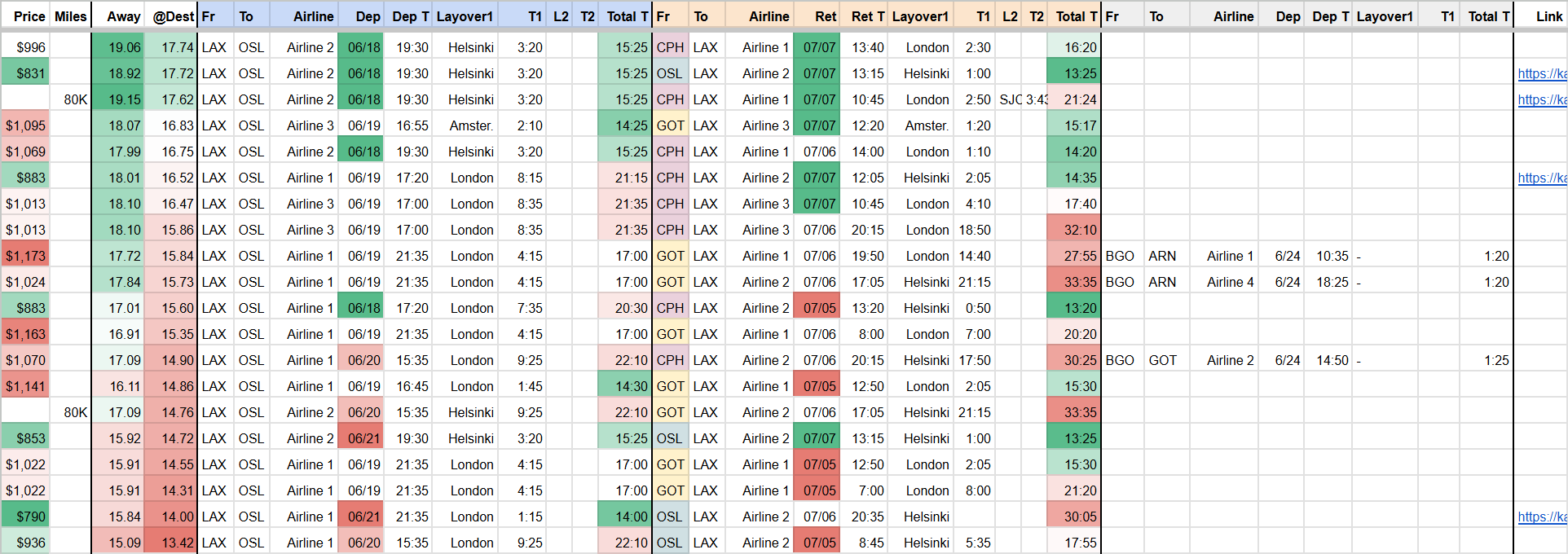
Create a new tab in your Trip Spreadsheet with flights you are considering and key metrics: time at destination, departure/arrival times, price/miles, layovers and layover time. Several columns below use conditional formatting to visualize the scale of the metrics. The table is also sorted by the number of days at the destination, and you can compare other metrics to make trade-offs. Is a flight worth an extra $80 if it let's you stay another 10 hours at your destination or avoids a layover?
Types of Flights
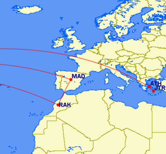
- Multi-city flights are time-efficient ways to see multiple destinations that may be difficult to reach via rails and roads, i.e. Home → Madrid → Marrakech → Home.
- Open Jaw (like a crocodile) flights are searchable as “Multi-city,” typically A → B and C → A where both legs of your ticket are in a single booking, but you are responsible for getting from B → C, whether by train, bus, ferry, or a separate 1-way flight.
- Nested Flights are Round-Trip tickets booked within another set of tickets. If you want to do a side trip to Santorini, it may be cheaper and more convenient to book Athens → Santorini → Athens than a multi-city Home → Athens → Santorini → Home, even if the last leg has a layover in Athens. Nested flights also give you the option to include them anywhere during a bigger trip (2 days Athens, 3 days Santorini, 2 day Athens) and not immediately before or after the Athens portion.
- Hacker Fares are just like round-trip or multi-city flights, but on separate bookings for lower fares, i.e. Home→Sydney on Qantas and Sydney→Melbourne→Home on Virgin Australia. Kayak.com lists these flights and labels them as such.
Layovers
Unless you live near a major airport, there are likely few direct flight options to your destination(s). But layovers can be an opportunity to explore a new major city.
The ideal layover would be 6-12 hours during daylight and to an airport with accessible transportation to a major city. In many European airport hubs, you can reach the city center via train in less than 30 min.
If you check your bags before the flight, you can navigate more easily through airports, stations, and city streets. However, most airlines now charge for checking baggage. Either way, you’ll want to have luggage as portable as possible (carry-on size pack or less).
Treat layovers like mini-trips that need to be researched, organized, and booked because time is more critical and there is less room for error by missing a connection.
Sites like Bounce, Stasher, NannyBag, or Radical Storage can hold your carry-on luggage for you if it’s too large to walk around with or you need to go into an attraction where it won’t be permitted.

Traveling Salesman Problem
In computer science, “The Travelling Salesman Problem” is about mastering the optimal route between a list of points. Your vacation just became a math problem.
Take a screenshot of your Trip Map so far, for marking up with lines and numbers. Where it makes sense, draw connections with locations that you might travel between, like from a major city to another city or to a natural park, beach, theme park, or venue outside major cities.
This map will help visualize which locations are worth the effort to reach and can be the first place that you have to cut destinations from the trip.
Wikivoyage Get In, Get Around
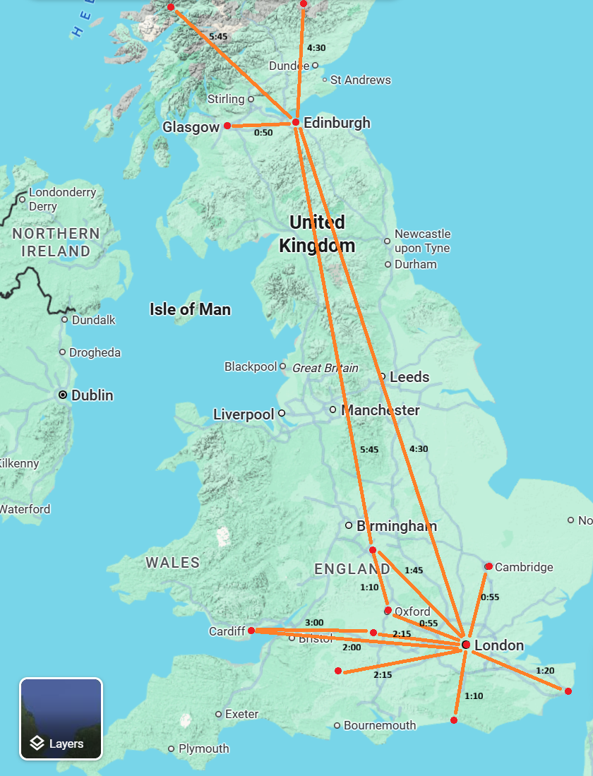
Wikivoyage is a community-edited online travel guide that contains great high-level information about a destination.
The Get In and Get Around sections are particularly helpful at this stage to understand how to get from airports or central stations to different parts of a city. It can detail several different modes of transport and you can weigh which one suits you best and where to book tickets once you have a more detailed plan.

Rome2Rio
For getting from Point A to Point B, Rome2Rio is an extremely valuable tool to understand different transportation options (Air, Rail, Bus, Metro, Ferry, Car, Taxi, Rideshare, On Foot) and the schedules associated with those options.
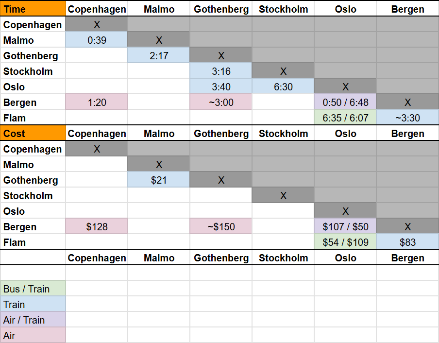
Just enter any two locations and the site will outline several transport options with travel time and pricing, even if they don’t make the most sense logistically. You can also create a Travel Distance Matrix (like on road maps) to visualize the Time and/or Cost of navigating between points.
When looking at transportation options between separate accommodations, it can be convenient to schedule these around common check-out/check-in times (11am - 3pm) so you can take your belongings from one hotel, bring them on your train/bus/flight, and then check-in to your hotel at your new destination (or at least drop off bags if the room is not ready yet).
Check: Car Rental
If you are traveling by rental car at some point in your trip, do a quick check that what you had in mind is both available and not an exorbitant price. Reservations for vehicles during summer months or high-profile events near smaller cities can fill up, so do a sanity check and get a better idea what vehicle options are available at certain price points.
For certain distances, it may make sense to rent a car one-way. Consider picking up the vehicle near the end of your stay in one city, making a couple roadside stops that would be difficult with public transportation or tours, while continuing to the next destination.
Request Time Off of Work

Book: Flights
Booking a flight is the first domino in making a trip a reality, but there’s a few considerations in (paying to) pick a seat to make a flight more enjoyable and less grueling. Once you have your flights selected:
- Take a look at the flight paths on Great Circle Mapper to know what interesting locations you’ll be flying over, like ice sheets, coral reefs, or desert dunes.
- Even more accurate flight paths can be found on FlightAware, helpful to know the paths arriving into your destination airports and which side of the plane sees what.
- For avoiding the sun on red eye flights or just reducing window glare, SunCalc.org has great visualizations of where the sun will be at any time, date, and location.
- SeatMaps.com outlines the aircraft you’ll be flying with details about which seats are not desirable, which have outlets, or which can’t recline.
- Finally, all else being equal, select the closest seats to the front as these will most likely deboard first.